|
The Southern Alps Foreland System, New Zealand
The West Coast region of the South Island and adjacent areas offshore occupy a domain of Australian crust that collides with the Pacific crust along the Alpine Fault. The Australian crust has the imprint of a lengthy deformation history (Paleozoic-Early Cretaceous terrane accretion at the Gondwana margin; Late Cretaceous to Eocene rifting; compressional inversion of earlier faults coeval with the development of the Pacific-Australia plate boundary since 25 Ma) and its ongoing shortening is testified by a record of large (M6–M7) historical earthquakes. To date there is no scientific consensus on the mechanisms driving this deformation, but some authors interpret the deformation as resulting from the flexural bending of Australian lithosphere beneath the orogenic wedge of the Southern Alps.
The major problem posed by this region is that existing geodynamic models cannot satisfactorily explain the geological evolution at the basin scale. Preliminary analyses conducted so far (Sibson and Ghisetti, 2010) show that the long wavelength, gentle eastward bending of the Australian basement monocline is strongly perturbed by pre-existing normal faults reactivated with reverse mechanisms, resulting in short-lived pulses of differential subsidence/uplift. As a result, the Neogene basins (~25–2 My old) developed within the Australian crust do not show the regular migration in space and time from the hinterland (Southern Alps) to the offshore regions of the South Island (Australian foreland) that typifies other comparable settings worldwide.
A better understanding of the tectonic driving processes is strongly needed and requires a multidisciplinary approach that has not so far been attempted. This research project proposed integrates stratigraphy, regional geology, surface deformation and subsurface data with the goal of reconstructing the evolution of sedimentary basins formed in a wide deformation belt west of the Alpine Fault. This study will provide the basis for an evolutionary model of foreland systems superposed onto domains of previously deformed crust and adjacent to a belt of strongly localised vertical and horizontal mobility. The results of this project will contribute to improved definition of the regional tectonics of the South Island and will have implications for seismic hazard and for the definition of 3D migration paths of hydrocarbon fluids in the reservoir/trap systems of the foreland basins.
The Castle Hill basin is a structural depression between uplifted ranges of Mesozoic basement. Before going into details about the Castle Hill basin, we describe the geometry of the Castle Hill basin. Figure 1 shows schematically the relationship between the Alpine Fault in the west and the thrust systems east of the Main Divide of the Southern Alps.
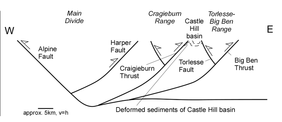
Fig.1. The Alpine Fault is interpreted as the surface expression of a mid-crustal shear system. The thrusts to the east of the Main Divide are thought to propagate eastward and the west-dipping thrusts have developed and east-dipping backthrust, e.g. the Torlesse fault is the backthrust to the west-dipping Big Ben thrust.
The oldest of these thrust systems is the Harper Fault. The supposedly next youngest backthrust is the Craigieburn Thrust, which is the western boundary of the Castle Hill basin. The Craigieburn Thrust has a backthrust associated with it. The backthrust formed subsequent to the Craigieburn Thrust and the thrust/backthrust-pair defines the Craigieburn Range pop-up. The next youngest thrust is the Big Ben Thrust with another associated backthrust, the Torlesse Fault. This thrust/backthrust system delimits the Torlesse-Big Ben Range pop-up, which is the southeastern margin of the Castle Hill basin.
The basin preserves a transgressive-regressive succession of Cretaceous-Tertiary strata, which have been folded and faulted during the Kaikoura Orogeny (Bradshaw, 1975). The basin is structurally controlled by two major range bounding thrust systems and is progressively being deformed and overridden by Mesozoic basement. It is generally assumed that the main ranges become successively younger eastward and progressively override the Canterbury Plains, however, quantitative data on the propagation is lacking.
For better understanding the inversion-style tectonics of the Castle Hill Basin and the surrounding ranges, structural mapping of the Torlesse rocks in the Craigieburn, Torlesse and northeast end of the Big Ben ranges will be completed. Geochronology work on the major fault zones and (U-Th)/He dating of uplift in the Craigieburn and Torlesse Ranges will shed light on the development of Castle Hill basin and has implications for the geological evolution of the wider North Canterbury region.
Our preliminary mapping in the northern part of the Castle Hill basin suggests that the folds, which characteristically have amplitudes on the 100m-scale, are fault-propagation folds. In other words, they are related to and being caused by underlying thrusts (the Craigieburn Thrust system) and the folds successively form as the thrusts are propagating forward.
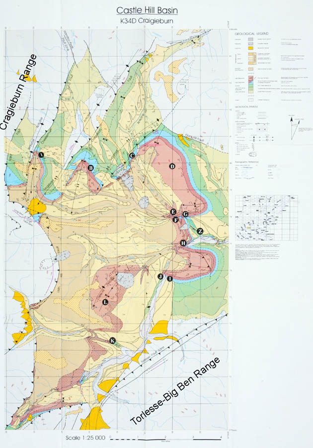
Fig.2. Geological and tectonic map of the Castle Hill basin (according to Jongens 1998). A fold-and-thrust belt developed east of the Craigieburn Range but not northwest of the Torless-Big Ben Range.
Our preliminary work also shows that the thrusts of the Craigieburn Thrust system, and also the Torlesse Fault, are associated with fault gouge (which is highly crushed incohesive fault rock). The latter is suitable for absolute age dating by the 39Ar/40Ar method, work that is being carried out with colleagues from the University of Western Australia in Perth. This in turn means that: (a) by dating fault gouge of a successive sequence of thrusts (and indirectly the associated folds) of the Craigieburn fold-and-thrust belt we will be able to constrain the age of the Craigieburn Thrust and also the speed at which the thrusts of the Craigieburn Thurst system propagated into the basin. We will also be able to constrain the age of the Torlesse Fault, which together with the apatite (U-Th)/He ages should enable us to tie down the structural evolution of the faults, and associated range uplifts, on both sides of the Castle Hill basin in great detail. |